
You might be deciding between a sunrise walk above the Pacific, a shaded canyon outing where children can explore at creek level, or a demanding backcountry climb that earns its views one steep switchback at a time. San Diego makes all three possible, often within the same trip.
The region's trail system is unusually broad for a major metropolitan area. San Diego County Parks manages more than 400 miles of trails across more than 159 parks, preserves, and facilities, while county recreation pages describe nearly 400 miles crossing coastal, mountain, and desert habitats San Diego County Parks trail information. That variety gives first-time visitors, families, couples, corporate groups, and active travelers plenty of ways to build a day outdoors without sacrificing comfort or good planning.
This guide sorts 10 hiking trails in San Diego from accessible coastal routes and family-friendly canyon walks to moderate city summits and strenuous inland adventures. Each pick includes the practical details that shape the experience, including distance, elevation, timing, parking, fees, transit considerations, seasonal conditions, water, footwear, and exposure. Trail figures can vary by route choice and access point, so confirm current conditions before leaving.
Travelers staying in La Jolla, downtown, or elsewhere in San Diego can pair a hike with beaches, neighborhoods, dining, or photography stops. If you'd rather leave the logistics to someone else, Another Side Of Los Angeles Tours can also be considered for guided transportation or a custom hiking-and-sightseeing day.
Table of Contents
- 1. Torrey Pines State Natural Reserve Razor Point Trail
- 2. Torrey Pines Guy Fleming Trail
- 3. Mount Soledad Veterans Memorial Trail
- 4. Sunset Cliffs Natural Park Sunset Cliff Trail
- 5. Los Peñasquitos Canyon Preserve Canyon Trail
- 6. Daley Ranch Daley Lake Trail
- 7. Cowles Mountain Summit Trail
- 8. Mount Woodson Potato Chip Rock Trail
- 9. Eagle Peak Volcan Mountain Trail
- 10. Los Peñasquitos Canyon Waterfall Trail Extension
- 10 San Diego Hiking Trails Comparison
- Build the Right San Diego Hiking Day
1. Torrey Pines State Natural Reserve Razor Point Trail
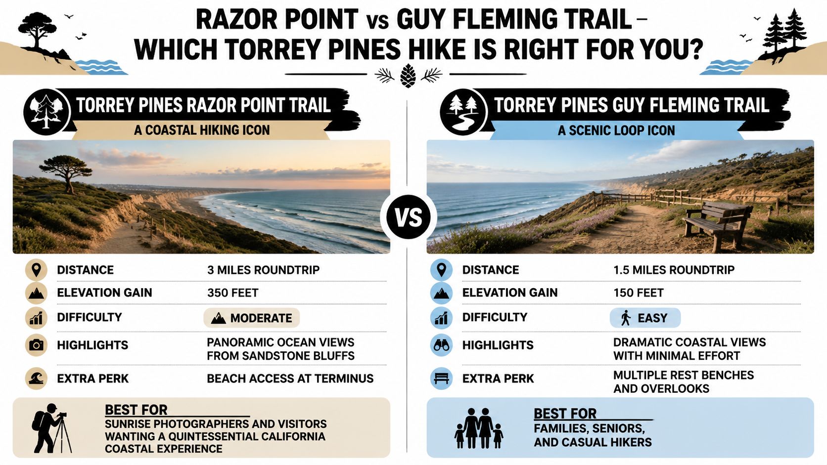
Razor Point is the classic coastal introduction to San Diego hiking. The route covers about 3 miles round-trip, with sandstone cliffs, coastal chaparral, native Torrey pines, and broad Pacific views that feel especially polished when the morning light reaches the bluffs. The reserve sits just north of La Jolla, making it easy to combine with a coastal drive, brunch, or time around La Jolla Cove.
The route is moderate rather than effortless. Sandy and loose sections can slow the descent, and the exposed ridge provides little shade. Sturdy hiking shoes with dependable grip are a better choice than casual sneakers, particularly if you're carrying a camera or moving with a family group.
Best timing and planning
Arrive early, ideally before 9 a.m., when parking is easier and the trail feels calmer. Early morning and late afternoon also offer the most attractive photography, while afternoon sun can make the sandstone and open ridges feel considerably hotter than expected.
Carry at least 2 liters of water per person, plus sunscreen, a hat, and UV-protective sunglasses. There's no reason to rush the viewpoints, but don't linger near unstable cliff edges or treat the beach descent as an informal shortcut.
Practical rule: Coastal scenery doesn't mean cool conditions. Plan Razor Point as an exposed hike and dress for sun, not just ocean breezes.
Couples often choose this route for a sunrise outing before a La Jolla meal, while first-time visitors appreciate how quickly it delivers the signature Southern California combination of cliffs, pines, and ocean. For broader regional planning, this Southern California beaches map can help connect Torrey Pines with nearby coastal stops.
If three miles feels longer than your group wants, Guy Fleming Trail offers a shorter alternative in the same reserve. Save the longer route for travelers who want more trail time, and choose an early start when the priority is atmosphere and photography.
2. Torrey Pines Guy Fleming Trail
Guy Fleming Trail is the efficient choice for dramatic scenery without a demanding outing. The loop is about 1.5 miles round-trip, and it stays within Torrey Pines State Natural Reserve, where visitors still encounter native pines, sandstone formations, coastal vegetation, and ocean-facing overlooks.
That compact scale makes it particularly useful for families with young children, older relatives, and first-time hikers who want a genuine coastal experience without committing to a longer route. It also works well as a confidence-building walk before adding Razor Point or another activity to the day.
A compact route with real exposure
The trail may be short, but the ridge is still exposed. Bring 1 to 2 liters of water per person, sunscreen, a hat, and sunglasses, and wear closed-toe shoes with enough grip for sandy ground. Starting early helps with parking, temperature, and the overall pace of a multigenerational group.
Spring can add wildflowers along the route, while the visitor center provides useful context about Torrey pine ecology and local geology. That interpretive stop is valuable for children because it turns a scenic walk into a place-based experience rather than a quick viewpoint visit.
- For families: Allow time for questions and observation instead of treating the loop as a race.
- For seniors: Use the shorter distance to preserve energy for La Jolla afterward.
- For active visitors: Add Razor Point if everyone still feels comfortable after the loop.
A private guide can be helpful when a group includes different walking abilities. One person may want photography time, another may prefer interpretive information, and children may need frequent pauses. A guided itinerary keeps those preferences coordinated without forcing everyone into the same pace.
Guy Fleming is also a smart first stop for travelers staying in La Jolla or arriving from Los Angeles who want an elegant coastal morning before continuing to other San Diego highlights. It gives you a clear sense of the reserve without consuming the entire day.
3. Mount Soledad Veterans Memorial Trail
Mount Soledad suits groups seeking a short climb with a meaningful destination. The route is about 2.1 miles round-trip with roughly 373 feet of elevation gain, ending at the Mount Soledad Veterans Memorial and views toward La Jolla, Mission Bay, and the Pacific.
The memorial gives this outing more depth than a standard viewpoint walk. Military families and veterans may find space for reflection, while children get an approachable introduction to San Diego's hills. The summit also works well for an anniversary, proposal, or quiet sunset pause, although exposed terrain and limited shade make midday less comfortable.
Making the summit part of a La Jolla day
Weekday mornings generally make parking and the climb calmer than busy periods. Bring sunscreen, a hat, sunglasses, and 1 to 2 liters of water for the exposed sections. A light jacket helps when ocean breezes reach the summit, particularly in the morning or near sunset.
Comfortable walking shoes work for most visitors. Heavy boots add little on this maintained route, but a secure sole is useful on the incline and any sandy patches. Allow time at the memorial rather than treating the hike as a quick photo stop.
Visitors come for personal and historical reasons, so keep voices low around the names and displays. Afterward, continue to La Jolla Cove or Children's Pool for a coastal finish. That pairing creates an efficient half-day itinerary, with the hill first and the waterfront afterward.
A private tour adds value for travelers arriving from Los Angeles who want transportation, timing, and local interpretation handled together. A Los Angeles to San Diego day trip can include Mount Soledad with coastal landmarks, avoiding the need to coordinate parking, navigation, and the return journey independently.
Choose Mount Soledad for a scenic climb with cultural weight and convenient La Jolla access. It offers little wilderness solitude, yet its manageable effort makes it a strong fit for a polished half-day itinerary.
4. Sunset Cliffs Natural Park Sunset Cliff Trail
Sunset Cliffs rewards a carefully timed visit more than a rushed finish. The coastal route runs about 3.5 miles out and back along sandstone bluffs above the Pacific near Ocean Beach, with secluded coves, coastal sage scrub, and broad ocean views. Its moderate walking demands and dramatic setting suit couples, photographers, and visitors planning a scenic coastal stop rather than a summit hike.
Plan to arrive 2 to 3 hours before sunset. Reaching the park just before golden hour often means circling for parking, sharing crowded viewpoints, and losing the best light before the walk begins. An earlier arrival leaves room to park, explore at an unhurried pace, and choose a safe viewpoint before the evening rush.
Build the evening around the coastline
Closed-toe shoes provide better protection on loose, crumbly sections near the bluffs. Keep well back from every edge, and do not treat the shoreline below as an easy extension of the trail. Waves and currents can turn lower coves and tide-pool areas hazardous, even when the water appears calm.
Facilities are not positioned along the route, so carry water and snacks. A light sweater or jacket helps once the wind strengthens after sunset. Lock the vehicle and keep valuables out of sight, particularly during the busiest evening period.
Use the trail to shape the outing:
- Couples: Choose a specific viewpoint, then continue to Ocean Beach for dinner.
- Photographers: Return in different weather and light conditions instead of relying on one sunset.
- Families: Keep children beside adults near every exposed section and skip risky descents.
Lower-cove exploration may be possible during low tide, but check conditions before approaching the water and respect the shoreline. Patience produces a better visit than aggressive route-finding.
A private guide is most useful when photography drives the itinerary. Local knowledge can simplify arrival timing, viewpoint selection, walking pace, and the transition to a later meal, especially when the group wants strong images without managing navigation during peak crowds. Downtown access is convenient, but it does not remove the need to plan for parking, wind, and fading light.
5. Los Peñasquitos Canyon Preserve Canyon Trail
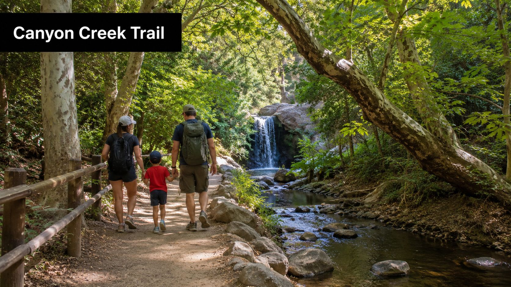
Los Peñasquitos Canyon feels surprisingly removed from the city. The main canyon outing described here covers about 6 miles round-trip, following a creek through riparian vegetation, oak groves, seasonal waterfall areas, and historic adobe remains. Its gentle character makes it a strong choice for families, first-time hikers, and anyone who prefers shade and nature immersion over exposed coastal ridges.
The canyon also works well as a repeat visit. Seasonal water, changing vegetation, and wildlife observation give families and school groups reasons to return rather than treating the preserve as a one-time attraction.
Water, mud, and changing access
Spring, especially February through April, can bring fuller waterfalls and wildflowers. Start early for cooler conditions and more shade, and bring sturdy waterproof footwear because creek crossings and muddy patches can make ordinary walking shoes uncomfortable.
The creek is a natural feature, not a dependable water source. Carry your own water, even when the channel appears to run continuously, and check conditions after heavy rain because crossings can become hazardous.
A creekside picnic can make this a satisfying half-day outing, but build in extra time if children want to wade or rock-hop. That flexibility is one reason the preserve works better for families than a rigid summit itinerary.
San Diego's large trail network means route status can differ between nearby segments. A recent local report highlighted that one Los Peñasquitos route remained open while a nearby Adobe Loop had a fire closure, with some listings lagging behind current updates local trail closure and heat-safety coverage. Check the exact access point and segment before setting out, not just the preserve name.
For corporate groups, a private guide can simplify meeting logistics and keep a mixed-ability team together. The canyon offers conversation, interpretation, and movement without demanding that every participant complete a steep climb.
6. Daley Ranch Daley Lake Trail
Choose Daley Ranch when a quieter inland morning fits the itinerary better than a crowded coastal viewpoint. The Daley Lake loop covers about 4.5 miles round-trip in Escondido, crossing oak woodland, coastal chaparral, open habitat, and the lake area. Its rustic character offers a genuine outdoor outing without the commitment of a remote backcountry route.
The trail works well for travelers who prefer observation over spectacle. Birdwatchers can carry binoculars, photographers can follow seasonal changes, and families get more space to pause than on San Diego's heavily visited routes. The trade-off is clear: Daley Ranch provides inland scenery, not an iconic ocean photograph.
Choose the season for the best conditions
Plan for March through May if wildflowers and higher lake levels are priorities. Conditions vary in summer and during drought years, so check current information before promising a full lakeside experience. Water levels may be limited, and swimming or wading should not be part of the plan unless park guidance specifically allows it.
Early starts make the route more comfortable and improve the chance of seeing wildlife. Bring 1.5 to 2 liters of water per person, snacks, comfortable hiking shoes, and sun protection. The trail is not a technical mountain climb, but inland heat and exposure can make an otherwise moderate walk tiring.
A simple packing plan:
- Bring binoculars when bird observation matters more than covering distance quickly.
- Carry a camera for oak woodland, reflections, and seasonal color.
- Leave room in the itinerary for quiet pauses rather than treating the loop as a timed workout.
Daley Ranch suits a private family or small-group morning followed by Escondido dining or another inland stop. A guide adds value when guests want help identifying birds and plants, or when a mixed-ability group needs a relaxed pace and clear route management. Independent hikers can handle the outing comfortably with current access information and adequate water.
San Diego's municipal open-space system includes 237 miles of trails, with major preserves accounting for much of that network San Diego hike and preserve overview. Daley Ranch shows why trail selection should account for atmosphere, heat, access, and the rest of the day, not only name recognition.
7. Cowles Mountain Summit Trail
Cowles Mountain gives visitors a genuine summit outing without leaving the city. The commonly used route covers about 3 miles round-trip and climbs roughly 950 feet, making it shorter and steeper than alternate approaches. Expect sustained uphill work on exposed, rocky ground.
Cowles sits inside Mission Trails Regional Park, one of San Diego's major open-space destinations. The park includes roughly 40 to 42 miles of trails and a 14,000-square-foot Visitor & Interpretive Center Mission Trails Regional Park information. That larger network makes the mountain easy to pair with a visitor-center stop or another trail, provided the group has enough time and water.
Treat the descent as part of the hike
Start before 7 a.m. for cooler temperatures, better parking prospects, and a more manageable climb. Carry more than 2 liters of water, consider an electrolyte drink, and wear closed-toe footwear with ankle support. Shade is limited, so sun protection matters even on a short itinerary.
The descent requires as much attention as the ascent. Trekking poles can reduce knee strain, while a controlled pace is safer than rushing once the summit is behind you. Check current conditions and maps at the Mission Trails visitor center before adding distance elsewhere in the park.
The steep return is where casual footwear and impatience create problems. Save energy for coming down.
Sunrise is the signature experience, with broad views toward downtown, the bay, surrounding mountains, and Pacific-facing horizons. Fitness groups also use Cowles for repeated uphill training, but visitors can treat it as a scenic summit hike rather than a speed challenge.
Another Side Of Los Angeles Tours offers Los Angeles hiking tours for travelers who want help with pacing, transportation, and interpretation across a broader Southern California itinerary. Cowles suits active visitors planning a focused morning. A private guide adds value when a group combines hikers with guests who prefer viewpoints, local context, or city experiences.
8. Mount Woodson Potato Chip Rock Trail
Mount Woodson is the choice for travelers who want a demanding hike with a recognizable visual payoff. The route described here is about 6.8 miles round-trip and gains roughly 1,400 feet, climbing through chaparral and oak woodland toward Potato Chip Rock in Ramona.
The formation is narrow, exposed, and visually dramatic. Photographing it from the approach is a completely valid way to enjoy the landmark, particularly if anyone in the group isn't comfortable with exposed scrambling or balancing near an edge.
Start before the heat builds
Start before dawn when possible. The trail offers limited shade, and the inland heat can turn a manageable climb into an unnecessarily punishing outing. Bring more than 3 liters of water, electrolytes, high-calorie snacks, sun-protective clothing, a hat, and sunglasses.
Trekking poles help on the steep descent, while moisture-wicking layers are more useful than heavy clothing. Fill the vehicle before leaving town because the trailhead is roughly 45 minutes from downtown San Diego, and the drive is too long to treat casually.
Spring, particularly March through April, and fall, particularly October through November, are generally more comfortable periods for planning this hike. Summer requires especially conservative judgment. Recent heat conditions have led officials to close strenuous backcountry areas, including the San Diego River Gorge and Three Sisters, after safety and wildfire-access concerns were raised coverage of heat-related closures. Always verify the current status of the exact route.
A private guide can make sense for content creators who need help with timing and photography, or for couples who want the adventure without improvising every transport detail. The guide should never pressure anyone onto the rock. The strongest image may come from a safe viewpoint below it.
9. Eagle Peak Volcan Mountain Trail
Set aside a full inland day for Eagle Peak. The trail runs about 5 miles round-trip with roughly 1,100 feet of elevation gain, passing through oak woodland and chaparral before reaching ridge views across San Diego's backcountry, Julian's mountains, and distant valleys.
Its quieter setting suits active couples, experienced small groups, and travelers who prefer open scenery to a heavily promoted attraction. The loose, rocky ground requires deliberate footing, and the climb can serve as measured preparation for more technical mountain outings.
Plan around the ridge, not only the summit. Leave early for cooler temperatures and simpler parking. Bring 2 to 3 liters of water per person, substantial snacks, trekking poles, and sturdy boots with dependable grip. Summer heat builds quickly on exposed sections, so schedule the route in spring, particularly March through May, or fall, particularly October through November.
Allow time to pause at the top. Clear conditions can reveal broad backcountry views, and an unhurried break makes the drive inland feel worthwhile. A private guide adds value when the day combines the hike with a later Ramona stop or winery visit, since someone else can coordinate timing, driving, and the return route.
- For couples: Pair a quiet ridge break with an inland meal or tasting.
- For fitness-focused hikers: Treat the ascent as controlled training rather than a race.
- For visitors from the coast: Build in time for the drive and the warmer inland climate.
San Diego County's trail-use planning materials report that 34% of surveyed county households use trails, about 12% of trail users hike more than once a week, and 39% typically choose hikes of five miles or more San Diego County trail planning facts. These figures support a practical approach to route choice. Difficulty, heat, parking, and driving time belong in the itinerary alongside scenery.
Eagle Peak rewards preparation and a flexible schedule. It does not suit a spontaneous coastal afternoon, but it can anchor a well-planned backcountry and wine-country day.
10. Los Peñasquitos Canyon Waterfall Trail Extension
The extended Los Peñasquitos route takes the preserve's shaded canyon experience farther upstream. The outing covers about 8 miles round-trip, with additional creekside travel, seasonal waterfall areas, and quieter sections beyond the shorter canyon walk.
Its value comes from immersion rather than a single dramatic summit. Nature photographers can spend meaningful time documenting seasonal changes, while birdwatchers and families can explore at a slower pace. The route remains easy to moderate in character, but the added distance changes the planning requirements.
Pack for a full canyon day
Start early so the group can finish comfortably before dusk. Carry 2 to 3 liters of water per person, a trail lunch, and waterproof, high-traction footwear. Don't rely on creek water, even when the channel appears inviting, and check conditions after heavy rain because crossings can become impassable.
Allow time for wildlife observation and creek exploration rather than scheduling a tight appointment immediately afterward. The extension is better for travelers who want a full nature day than for visitors trying to fit several unrelated attractions into a few hours.
Route status also deserves careful attention. County open-space rules require visitors to remain on designated trails and prohibit overnight camping, open fires, firearms or weapons, littering, feeding or harassing wildlife, and motorized vehicles on trails San Diego Open Space Canyons and Parklands rules. Those restrictions affect how families pack, how groups behave near wildlife, and whether an outing can reasonably continue into the evening.
The San Dieguito River Park system provides another useful example of why opening hours matter. Its plan says trails open at 6 a.m. daily, close at 6 p.m. from October 1 through March 31, and close at 7:30 p.m. from April 1 through September 30; it also notes that trails not shown on official maps aren't authorized and may close at any time San Dieguito River Park Trails Master Plan. Rules vary by preserve, so check the governing agency for your exact route.
10 San Diego Hiking Trails Comparison
| Trail | 🔄 Difficulty & Complexity | ⚡ Distance / Effort | ⭐ Expected outcomes | 💡 Ideal use cases | 📊 Key advantages |
|---|---|---|---|---|---|
| Torrey Pines State Natural Reserve – Razor Point Trail | Moderate, sandy/loose sections; 350 ft gain; viewpoint platforms; moderate crowds | 3.0 mi RT · 350 ft · Parking often fills · Bring 2L water | ⭐⭐⭐⭐⭐ Panoramic sandstone bluffs, beach access, excellent sunrise photography | Photographers, first‑time coastal visitors, families with moderate fitness | Iconic coastal views; well‑maintained; visitor center; beach access |
| Torrey Pines – Guy Fleming Trail | Easy, short loop; 150 ft gain; benches; very accessible | 1.5 mi RT · 150 ft · Short duration · Bring 1–2L water | ⭐⭐⭐⭐ Dramatic coastal overlooks with minimal effort | Families, seniors, casual walkers, accessible sightseeing | Highly accessible; interpretive displays; peaceful; good for all ages |
| Mount Soledad – Veterans Memorial Trail | Easy, paved sections; 373 ft gain; memorial summit; mostly accessible | 2.1 mi RT · 373 ft · Easy parking relative to other trails · Bring 1–2L water | ⭐⭐⭐⭐ 360° city/bay/ocean views plus meaningful memorial experience | Families, veterans, visitors seeking views + reflection | Accessible summit; urban proximity; meaningful landmark; easier parking |
| Sunset Cliffs Natural Park – Sunset Cliff Trail | Easy–Moderate, exposed narrow cliffs; erosion risk; crowded at sunset | 3.5 mi O‑B · ~200 ft · No fee · Arrive 2–3 hr before sunset | ⭐⭐⭐⭐⭐ World‑class sunset photography and dramatic cliff vistas | Photographers, couples, sunset enthusiasts | Free access; urban convenience; dramatic sunset vistas; tide‑pool access |
| Los Peñasquitos Canyon Preserve – Canyon Trail | Easy–Moderate, creek crossings; shaded riparian terrain; 300 ft gain | 6.0 mi RT · 300 ft · Year‑round creek; waterproof boots after rain | ⭐⭐⭐⭐ Tranquil riparian oasis, seasonal waterfalls, wildlife viewing | Families, nature immersion, school groups, birdwatchers | Shaded creek, historic ruins, cool in summer, pet‑friendly, free parking |
| Daley Ranch – Daley Lake Trail | Easy, gentle loop; 300 ft gain; less crowded backcountry feel | 4.5 mi RT · 300 ft · ~35‑min drive · Bring 1.5–2L water | ⭐⭐⭐⭐ Peaceful lake views, wildlife and strong spring wildflower displays | Photographers, birdwatchers, solitude seekers, families | Less crowded; lake access (seasonal); wildflowers; free admission |
| Cowles Mountain – Summit Trail | Moderate, steady steep climb; 900 ft gain; exposed; popular | 4.8 mi RT · 900 ft · 15‑min from downtown · Bring 2+L water | ⭐⭐⭐⭐ High‑reward 360° urban/backcountry views; fitness accomplishment | Fitness hikers, sunrise seekers, locals | Closest city high‑point; well‑maintained; social hiking culture; no fee |
| Mount Woodson – Potato Chip Rock Trail | Moderate–Strenuous, long climb; 1,400 ft gain; exposed; heat risk | 6.8 mi RT · 1,400 ft · ~45‑min drive · Bring 3+L water | ⭐⭐⭐⭐⭐ Iconic Potato Chip Rock photos; panoramic backcountry vistas | Content creators, adventure seekers, fitness enthusiasts | Unique landmark; very high visual payoff; challenging training hike |
| Eagle Peak – Volcan Mountain Trail | Moderate, 1,100 ft gain; remote ridge; rocky/loose sections | 5.0 mi RT · 1,100 ft · ~45+ min drive · Limited cell/water | ⭐⭐⭐⭐ Rugged backcountry ridge views with greater solitude | Backcountry seekers, training hikes, wildflower observers | Far fewer crowds; dramatic ridgeline vistas; free parking; wine‑pairing options nearby |
| Los Peñasquitos Canyon – Waterfall Trail Extension | Easy–Moderate, longer route; 400 ft gain; deeper creek crossings | 8.0 mi RT · 400 ft · Full‑day distance · Waterproof boots recommended | ⭐⭐⭐⭐ More solitude, extended waterfall access and deeper canyon immersion | Fit families, nature photographers, day hikers seeking longer route | Extended solitude; richer canyon features; seasonal waterfalls; free parking |
Build the Right San Diego Hiking Day
The best hike depends less on a universal ranking than on the day you want to create. A family staying in La Jolla can begin with Guy Fleming or Razor Point, enjoy the visitor center, and continue to La Jolla Cove for an easy coastal afternoon. Mount Soledad works well when the group wants a shorter climb, a meaningful memorial, and broad views without committing to a full wilderness day.
Couples often get more from a timed experience than from selecting the most famous trail. Sunset Cliffs is ideal for a sunset-focused outing, provided you arrive early enough to park and walk before the light changes. Torrey Pines offers a calmer photography window in the morning, while Mount Soledad gives you a higher viewpoint with a more reflective atmosphere.
For warmer conditions, favor shaded canyon terrain and an early start. Los Peñasquitos Canyon's shorter route is better for families and first-time hikers, while the waterfall extension suits travelers who want a longer, slower nature day. Creek water doesn't replace carried water, and recent rain can change crossings quickly.
A Ramona itinerary should be treated as a full inland adventure. Mount Woodson and Eagle Peak both require more attention to heat, hydration, footwear, and driving time than a coastal walk. Pairing Eagle Peak with wine-country time can create a satisfying day, while Potato Chip Rock is better for hikers who specifically want the challenge and the landmark photograph.
San Diego's trail inventory supports this kind of segmentation. County Parks manages more than 400 miles across more than 159 parks, preserves, and facilities, so a single “best hike” answer often hides the practical question, which access point and route are appropriate today San Diego County Parks trail information. Closure zones, parking conditions, permitted paths, heat exposure, and trail surfaces can differ even within the same preserve.
Before leaving, confirm the current trail status with the responsible park agency. Calculate the complete door-to-door schedule, including driving, parking, walking to the trailhead, hiking, breaks, and the return trip. Carry enough water for the route and conditions, protect against sun and heat, and use footwear suited to sand, rock, mud, or creek crossings.
Respect the setting as carefully as the scenery. Stay on designated trails, keep away from unstable cliff edges, treat the Mount Soledad memorial with care, don't feed or harass wildlife, and don't assume a creek crossing is safe because other people are attempting it. The practical rules are part of a premium outdoor experience because they protect the place and keep the day from becoming an avoidable emergency.
A private guide is worth considering when your group needs private transportation, expert interpretation, flexible pacing, photography assistance, or a custom combination of hiking and sightseeing. That can be especially useful for visitors balancing a San Diego hike with Los Angeles plans, corporate groups coordinating different fitness levels, families carrying extra gear, or couples who want the day to feel effortless rather than self-managed. For footwear, travelers comparing lightweight trail options can also review this guide to the best trail runners for hiking.
Another Side Of Los Angeles Tours is a relevant option when you want a guided Southern California experience with logistics coordinated around your priorities. The right service won't make a strenuous hike effortless, but it can make the transportation, timing, interpretation, and transitions much easier to manage.
Another Side Of Los Angeles Tours can arrange guided hiking and sightseeing experiences for travelers who want private transportation, flexible pacing, photography support, or a custom San Diego day. Visit Another Side Of Los Angeles Tours to explore options and plan an itinerary that fits your group, interests, and preferred level of service.